Multimedia |
Messengers |
Desktop |
Development |
Education |
Games |
Graphics |
Networking |
Security |
Servers |
Utilities |
Web Dev
Home ›
Development ›
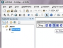
ST-Links QMap
ST-Links QMap
By ST-Links Corporation
Rating:
 0/5 (0)
0/5 (0)
License type:
Freeware
Home page:
www.st-links.com
Latest version:
2.0
Last updated:
October 24th, 2011
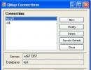
ST-Links QMap is an ArcMap extension created for directly using SQL Server 2008 /R2 spatial tables or views as ArcMap feature layers without ArcSDE or ArcGIS Server. With ST-Links QMap, ArcMap can...