Multimedia |
Messengers |
Desktop |
Development |
Education |
Games |
Graphics |
Networking |
Security |
Servers |
Utilities |
Web Dev
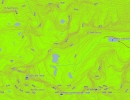
MT Topo - Public Lands
By Northwest Environmental Services
Rating:
 0/5 (0)
0/5 (0)
License type:
Freeware
Home page:
www.gpsfiledepot.com
Latest version:
2.1
Last updated:
October 31st, 2011
This mapset contains topographic, hydro, road, trail, POI, and public land data for the state of Montana. Topo lines dissipate quicker as zoom scale increases. Much improved over the Garmin 24K...