Multimedia |
Messengers |
Desktop |
Development |
Education |
Games |
Graphics |
Networking |
Security |
Servers |
Utilities |
Web Dev
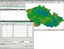
GRASS GIS
By GRASS Development Team, CC-BY-SA
Rating:
 0/5 (0)
0/5 (0)
License type:
Open source
Home page:
grass.osgeo.org
Latest version:
8.3
Last updated:
July 29th, 2020
Geographic Resources Analysis Support System, commonly referred to as GRASS GIS, is a Geographic Information System (GIS) used for data management, image processing, graphics production, spatial...